The Unique Maps Co.
Map of Show Low, Arizona by USGS, 1998 – Sitgreaves National Forest & Fool Hollow Lake
Map of Show Low, Arizona by USGS, 1998 – Sitgreaves National Forest & Fool Hollow Lake
Couldn't load pickup availability
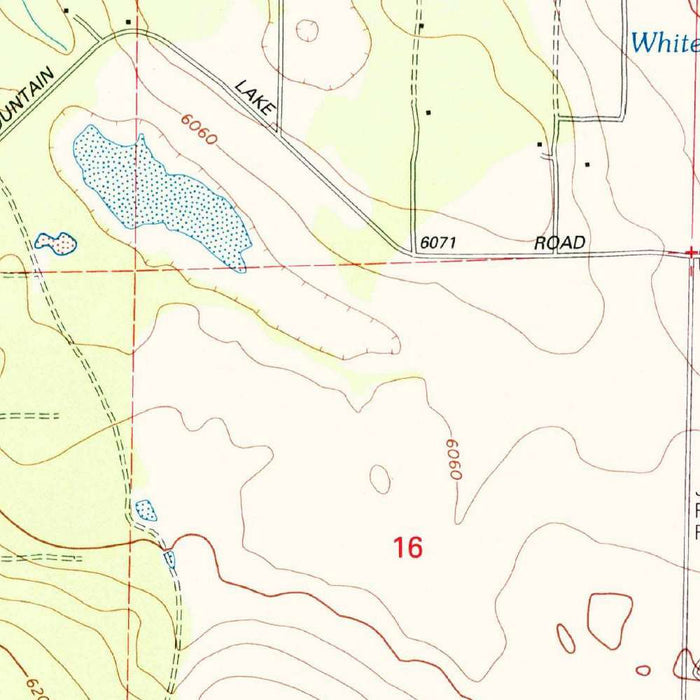
Titled “Show Low North,” this US Geological Survey 1:24,000 topographical map presents the northern reaches of Show Low, Arizona, and the surrounding high-country landscape. Dated 1998 and carrying a 2000 imprint, it captures the region at the turn of the millennium, when the White Mountains area was increasingly prized for recreation, forest access, and residential retreat. Show Low appears not as an isolated town, but as a community embedded in a wider terrain of roads, water, wooded slopes, and public lands. The precision of the USGS format gives the map both practical authority and historical charm, preserving a detailed moment in the evolving relationship between settlement, transportation, and Arizona’s elevated forest country.
The US Geological Survey brought to this map more than a century of institutional expertise in measuring and interpreting the American landscape. Founded in 1879, the USGS became synonymous with rigorous topographic mapping, producing quadrangles that guided engineers, planners, foresters, hikers, and government agencies alike. In “Show Low North,” that legacy is evident in the careful contouring, standardized symbols, and disciplined visual hierarchy. Roads, trails, water features, vegetation, boundaries, and relief are presented with a clarity that rewards close study. The map belongs to a cartographic tradition in which scientific accuracy and elegant utility meet, transforming a seemingly local Arizona sheet into part of a national project to understand the land in exacting detail.
Show Low itself occupies a fascinating position in Arizona geography, set within the higher elevations of the Mogollon Rim country rather than the desert imagery often associated with the state. The map reveals a landscape shaped by hills, valleys, forest cover, and seasonal water, with Fool Hollow Lake and other ponds contributing to the area’s recreational character. US Route 60 and State Route 77 help anchor the town within the broader transportation network, showing how movement through this mountainous region depended upon carefully routed corridors. Around the developed areas, the terrain quickly becomes more complex, emphasizing why topographical mapping was so essential here: elevation, drainage, and access define the character of the country.
One of the map’s most compelling features is its depiction of the Sitgreaves National Forest and adjoining lands used for recreation and government purposes. The forested setting is not merely decorative; it reflects a working landscape where conservation, timber management, wildlife habitat, public access, and tourism overlapped. Trails, secondary roads, and land-use boundaries hint at the practical rhythms of the region, from outdoor excursions to administrative oversight. The surrounding hills and wooded tracts convey the ecological richness of eastern Arizona’s highlands, a place of ponderosa pine, open meadows, and cool-air refuge. For collectors, this map offers a finely observed record of how public land, local infrastructure, and natural terrain were arranged at a precise historical moment.
Cartographically, “Show Low North” is a model of late twentieth-century USGS topographic design. Its contour lines articulate the rise and fall of the land with quiet sophistication, allowing the viewer to read slopes, ridgelines, basins, and drainage patterns almost three-dimensionally. Color differentiates forests, water bodies, built environments, and transportation features, creating an intuitive visual language that remains remarkably legible. The sheet invites both analytical study and imaginative travel: one can follow a road out of Show Low, trace the edge of a lake, or climb by contour into surrounding hills. As a historical map, it preserves not only geography, but the lived texture of a region where town, forest, and recreation meet.
Cities, towns and places on this map
- Show Low
- Fool Hollow Lake and other lakes or ponds
- Sitgreaves National Forest
- US Route 60
- State Route 77
- Land designated for recreational and government use
- Trails indicated on the map
- Topographic features such as hills and valleys
Historical context & cartographic details
- Produced by the US Geological Survey as a historical 1:24,000 topographical map.
- Dated 1998 with a 2000 imprint.
- Shows Show Low, Arizona, and the surrounding area at the time of publication.
- Created by the US Geological Survey, known for comprehensive geological and topographical surveys across the United States.
- Uses clear contour lines to show elevation changes across the hilly, forested terrain.
- Employs color to differentiate geographic features such as forests, bodies of water, and landforms.
- Provides insight into land use, natural features, development, and forestry practices as they appeared around 1998.
Looking for a particular place? Review the detailed images to confirm that the town, landmark or feature you have in mind appears on the map. If you are unsure, ask our workshop to check before you order.
Detailed maps are especially rewarding at larger sizes, where names, boundaries and decorative features have more room to be appreciated. Use the close-up preview and size guide to choose the right scale for your wall.
This map looks amazing at sizes all the way up to 50in (125cm). If you are looking for a larger map, please get in touch.
The model in the listing images is holding the 16x20in (40x50cm) version of this map.
Where personalisation is available, you can add a short title or dedication, mark one meaningful place, or request one considered visual detail. See personalised map examples.
Every piece is printed to museum-grade archival standards using fade-resistant pigment inks on acid-free matte paper. Choose an unframed map print, framed map or canvas using the finish options above. Framed maps use crystal-clear optical acrylic and arrive ready to hang.
With its rich detail and strong sense of place, this map makes a considered gift for a new home, anniversary, retirement or anyone with a personal connection to the area shown. Still deciding? Explore our collection of rare old and vintage maps to discover another place, period or style.
Share